~

~
Loma Alta

Tuesday, January 24, 2017

Angle of Repose: Almaden Quicksilver County Park

Almaden Quicksilver County Park
January 15, 2017

Map used today:
http://ridgetrail.org/images/interactive_map/maps/AlmadenQuicksilverCountyPark.pdf

Almaden Quicksilver County Park has been on our list to visit for longer than we have been hiking on the Bay Area Ridge Trail. Let me explain the title of this post:

Wallace Stegner's novel Angle of Repose is a favorite of ours. This book is based on the writings of Mary Hallock Foote, who lived with her engineer husband at the New Almaden Mine from 1876 until 1878. As we walked through the park, interpretive signs informed us of the succession of residents who mined and then processed cinnabar to retrieve the mercury. Find out more about the mining history here.

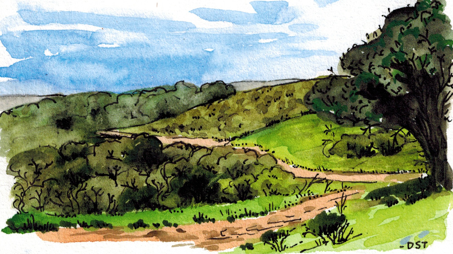
Our walk has inspired us to learn more about Mary Hallock Foote, her writing, and her artwork. In the late 1800's, she was probably the most famous American female author and illustrator alive, and her first published writing was her lengthy description of life in New Almaden. At the time, she was newly married, newly arrived from upstate New York, and soon to give birth to an 11-pound boy. You can read "A California Mining Camp" (1878) here. Scholarship around Foote's life and work is rich and inviting. Here is her version of the ridge line that Donna painted:

"Mexican Camp -- After the Fire" (1878)

As usual, we are deeply grateful to the Ridge Trail organization for yet another perfect walk, this one steeped in history, culture, and the voices of people from 150 years ago.

Misty trail through the oaks


The New Almaden Mine Ruins


Mt Umunhum wrapped with fog


The interpretive plaque in English Camp


Rusty barn in the mist

Here are some more photos from this wonderful day.


Monday, January 23, 2017

Rain on Beautiful Mount Madonna

Saturday, December 10, 2016
Mt Madonna County Park
Map used on this leg: http://ridgetrail.org/mount-madonna-county-park

Donna, Richard, and I took a short and sweet, wet and newt-filled, mushroom-rich walk on Mount Madonna, starting near the summit and working our way down.  With raincoats and a couple of umbrellas, this was an absolutely gorgeous stroll on the Ridge Trail.


Sunday, November 27, 2016

Sun on Coyote Ridge

Sunday of Thanksgiving weekend, 2016
Trail near Harvey Bear Ranch


Today we walked along Coyote Ridge from Harvey Bear Ranch south to Mendoza Ranch on a gorgeous Sunday after a rainy Saturday night. Our walk started with this ominous warning, below: the head of a mountain lion is almost as high as a bike's handlebars.


The views of the Santa Clara valley today were spectacular from the top of this eleven-year-old county park. The Calaveras Fault cuts through a landscape of rolling hills dotted with oaks and buckeyes. We saw several feral pigs, as well as deer, squirrels, red-tailed hawks, and from the road heading back out of the park, several wild turkeys. It was a perfect day to be out on the wonderful Bay Area Ridge Trail! In the photo below, we can see much of our circuit to the west and north.


Below, curly fungus at the base of an oak tree.


Photos of all of our BART hikes are here: https://photoenthusiast.smugmug.com/Other-1

Wednesday, June 29, 2016

Joseph D. Grant County Park

June 20, 2016
Milkweed, wildflower for monarchs

Map used today: http://www.ridgetrail.org/joseph-d-grant-county-park

On a hot day, Donna, Richard, Larry, and I converted an 11-mile out-and-back walk into a 10-mile one-way walk with approximately 2300 feet of total elevation gain. The great advantage of our modified route was that we were able to set up a car shuttle for a through-walk that gave us a great variety of terrain and views. So, rather than turning around at Panochita Hill, we continued to the east on the Cañada de Pala Trail.


Here is a screen shot of our modified route from the Gaia app.


Joseph Grant was the son of Adam Grant, who co-owned a wholesale dry-goods company in San Francisco. Murphy and Grant's overalls were a popular alternative to Levi Strauss's jeans during the Gold Rush. Grant, and later, his son James, bought parcels of the former Mexican land grant Rancho Cañada de Pala starting in 1880; and in the 1970's, Santa Clara County bought 9500 acres of the Grants' ranch to create a park. The remainder of the ranch was bequeathed to the Save the Redwoods League by James Grant's daughter.


Looking to the northwest, we can see our western ridge route and the faint profile of Mt. Tamalpais.


Part of our walk included a culvert leading to a cool (and cow-free) pond.


We ended our walk just below Mt. Hamilton and Lick Observatory.


On a very hot day, this might be a tough hike. Here's what you'll need:
  1. 3 liters of water
  2. a hat that you can fill repeatedly with some of those 3 L of water
  3. hiking poles from your kind hiking mates for extra locomotion ability
  4. margarita-flavored gel blocks from your kind hiking mates
  5. spicy beef jerky from those great mates
  6. wet neckerchiefs (2), also from your buddies
More photos of this fine walk are here:
https://photoenthusiast.smugmug.com/Other-1/Joseph-D-Grant-Park-62016/

Want to see the whole trip so far? https://photoenthusiast.smugmug.com/Other-1

Monday, May 30, 2016

Gathering Place: Alum Rock Park to Sierra Vista Open Space Preserve


Up the hill on the Boccardo Loop Trail

May 22 and June 5, 2016

Map used on this leg: http://www.ridgetrail.org/alum-rock-park-and-boccardo-trail-corridor

I call this post "Gathering Place" because Alum Rock Park  has been and continues to be a place for folks to gather and enjoy a picnic and hike since 1872! We ambled near smoky barbecues and tables heavily laden with food and drink.

Molly, Janene, and I made our way up the hill on Sunday the 22nd for another great day on the Bay Area Ridge Trail. The wildflowers are hidden now by the tall grasses, so the spectacular spring show is nearing completion, but the clouds and distant bay views were beautiful as usual. Compared to the last leg on Mission Peak, this hike was quiet and with many fewer other hikers.

Rather than making one through-hike, we broke this walk into two round trips, partly due to the lack of parking at the eastern terminus of the Sierra Vista trail.

We finished this walk on June 5, starting and ending at the staging area on Sierra Road. Peter, Janene, Julia, Kirsten, Richard, and David joined us on this half.


Mission Peak and the Bay


Mariposa lily


More photos from these two legs: https://photoenthusiast.smugmug.com/Other-1/Alum-rock-1/ and
https://photoenthusiast.smugmug.com/Other-1/Leg-19-Alum-RockSierra-Vista/

Photos from the whole walk so far: https://photoenthusiast.smugmug.com/Other-1

Monday, May 23, 2016

Mission Peak


Mission Peak trek
February 21, 2016

Map used on this leg: http://www.ridgetrail.org/mission-peak-and-ed-r-levin-county-park

We joined hundreds of hikers on a beautiful Sunday on our way up to the peak. Our friends Janene, Beth, and Marilyn joined us from Santa Cruz, and we got an early start to a stunning day-long 10.5 mile hike.


Here at the summit (2520'), peak baggers line up to climb the Mission Peeker, created by sculptor and park ranger Leonard Page in 1990. The Peeker combines tubes to look through, along with a time capsule sealed inside. In 2090, people will find such artifacts as an Ohlone charmstone replica, a picture of Bart Simpson, and a bottle of 1990 zinfandel. 


Do you notice that the rocks at the this hiker's feet tend to slant in the same direction? Mission Peak is the result of uplift and erosion as the North American Plate gets pushed and squished by the Pacific Plate. Planes of similar-slanting rocks are typical in this type of formation.

Below is the tremendous view to the south.


Here is an old fig tree.


More photos from this stunning day are here: https://photoenthusiast.smugmug.com/Other-1/Leg-17/

Our entire BART walk is here: https://photoenthusiast.smugmug.com/Other-1

Saturday, February 20, 2016

Walking Past Diablo: February 13-15, 2016

Chabot Regional Park

Trails used on this leg:

http://www.ridgetrail.org/redwood-and-anthony-chabot-regional-parks
http://www.ridgetrail.org/anthony-chabot-regional-park
http://www.ridgetrail.org/east-bay-mud-to-cull-canyon
http://www.ridgetrail.org/doncastro-drycreek

Over three wonderful days on the trail, we saw gorgeous redwoods, a trout run, lots of cattle, endless emerald-green hills, an observatory, blooming bay trees and trilliums, what's left of the farm of the late-1800's/early 1900's Ukrainian human-rights scholar and writer Agapius Honcharenko, beautiful expanses of the deep-blue bay, and Mt. Diablo from the south!!

These contiguous trails are absolutely stunning.


Old sea floor on the top of Rampage Peak


Mt. Diablo, our constant companion

More photos of this leg are here.

Photos of the entire trip so far are here