~

~
Loma Alta

Sunday, November 10, 2013

Days 7 and 8: Mt. Tamalpais


November 2-3, 2013

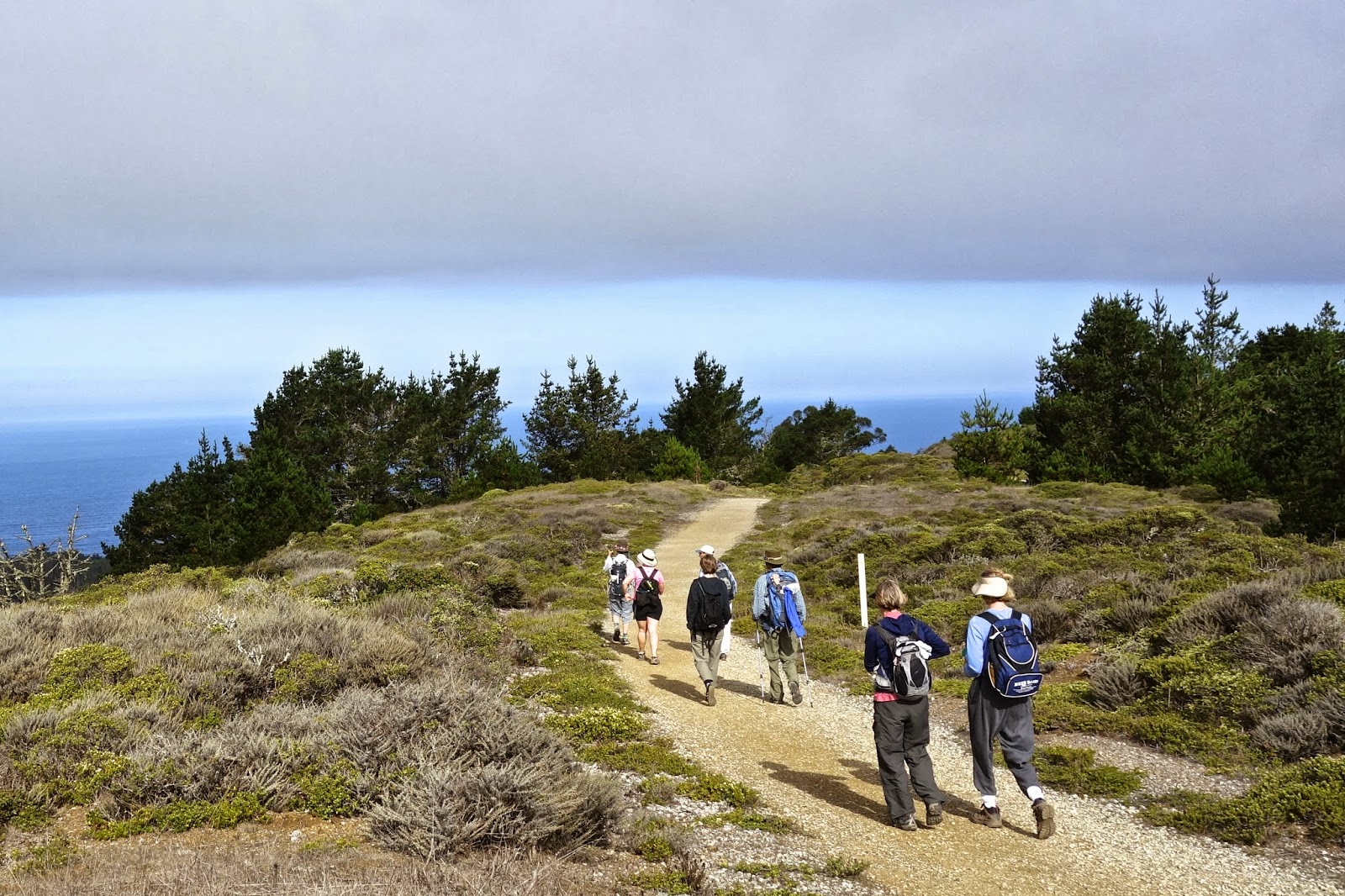
Stinson Beach and Bolinas from Bolinas Ridge

Maps used on this 2-day leg are:

http://www.ridgetrail.org/index.php/golden-gate-bridge-to-tennessee-valley

http://www.ridgetrail.org/index.php/tennessee-valley-to-shoreline-highway

http://www.ridgetrail.org/index.php/dias-ridge

http://www.ridgetrail.org/index.php/mount-tamalpais-state-park

http://www.ridgetrail.org/index.php/mount-tamalpais-state-park-and-ggnra

http://www.ridgetrail.org/index.php/ggnra-and-samuel-p-taylor-state-park

We were joined by our cheerful and indefatigable walking friend David again, this time for a 30-mile overnighter.  Donna and I left a car in the Presidio at her friend Mary's house.  Mary drove us to the north end of the Golden Gate Bridge, where we met David, who'd walked there from his house.  Our first day out was approximately 15 miles long; David's was over 20.

Here is the north end of the bridge at about 9:00 Saturday morning.


An hour later or so, we had our first view of Mt. Tam.  The mountain's elevation is 2575' currently; it used to be over 2600' tall before the summit was graded for the installation of radar equipment.

We will spend tonight near the summit at the Pan Toll campground.  There are walk-in sites -- no reservation necessary!  We found a great site, visited with a camping chef who is getting ready to open an unusual Thai restaurant in downtown San Francisco, and we cooked our morning oatmeal on Sunday over a fire due to a balky backpacking stove.


Day 2: Mt. Tam and the Bolinas Ridge (below) are bits of the North American Plate which have been pushed up as the plate slides over and along the Pacific Plate.  More evidence of this plate-to-plate interaction is the preponderance along the trail of green-black serpentinite, which is formed underwater at the interface.  Serpentine is our state rock.

We will now be firmly on the North American Plate for the rest of our round-the-bay walk.  


Mt. Tam State Park 


Sunday afternoon: Lagunitas Creek. and the end of our beautiful 2-day trek.  You can find more photos and information about this leg here.


Wednesday, October 9, 2013

Day 6: San Francisco, the Beautiful City

Painted from the Bay Area Ridge Trail in the Presidio, San Francisco

Saturday, October 5, 2013

Today we walk clear across San Francisco, from the southwest to Sausalito.  The official maps we are using are:

http://www.ridgetrail.org/index.php/fort-funston-to-stern-grove

http://www.ridgetrail.org/index.php/stern-grove-to-the-presidio

http://www.ridgetrail.org/index.php/san-francisco-presidio

http://www.ridgetrail.org/index.php/golden-gate-bridge


However, we have charted our own course today thanks to our San Franciscan friend David, who walks these streets all the time, and really knows his way around.  What's more, Ft. Funston was closed due to the shutdown of the federal government, so we started slightly north of there, on Brotherhood Way, and walked across the Lake Merced neighborhood.

Our route, in a nutshell, was: Brotherhood Way, Merced Heights, Joost St., Glen Canyon, Twin Peaks, Mt. Sutro, Golden Gate Park, the Presidio, and the Golden Gate Bridge.  It was a perfect walk for a perfectly sunny day.

Our crew today includes friends Suzanne, Julia, David, and Jonathan (for a bit at the beginning).

We are looking at the view, visible in the photo below.  We have just walked up the hill from Brotherhood Way and Temple Beth Israel-Judea to Merced Heights.


Walking along Joost Street, named after Behrend Joost.  You can read about him here.


Scaling Mt. Sutro


Finishing up a terrific 15-mile walk.  Thanks, David, for the excellent route.

More photos from the day here.

Friday, September 20, 2013

Day 5: We amble beside the Pacific Ocean

Pacific Ocean near Ft. Funston


Sunday, September 16, 2013

Maps used creatively today: 

Sweeney Ridge to Milagra Ridge

Mussel Rock to Fort Funston


Eight of us today -- our biggest group yet!  Donna and I walked to San Francisco today with Julia, Amy, Sandra, Katarina (visiting from Germany), David, and Peter.  As we descended Sweeney Ridge at around 10 in the morning, the fog began to clear.


This is the view of Pacifica and the Pacific from Milagra Ridge.


Here is Mussel Rock, a remnant of the Farallon Plate, which now lies mostly underneath the North American Plate.  The ancient seafloor that makes up Mussel Rock is much older and much more erosionally resistant than the 3-million-year-old sedimentary Merced Formation on the coast.

The epicenter of the 1906 San Francisco earthquake is about 2 miles offshore to the north of Mussel Rock.


This landslide above Mussel Rock was triggered by the 1906 earthquake.  The houses are more recent.


After much debate and careful consideration, Donna goes for it.  Fort Funston is two miles away up the beach.  As long as it's low tide and there's no catastrophic earthquake, this option is probably safe enough.  All eight of us made it.


More photos from today here!

Wednesday, August 28, 2013

Day 4: San Francisco Watershed


Saturday, August 24, 2013


We have chosen a perfectly gorgeous day for a 13-mile walk, part of which is inside a protected area of the SF watershed.  Our group today includes Beth, docent Bob, and Molly's son Alex.  Bob is a volunteer who leads walks (and unlocks gates) on the Fifield-Cahill Ridge Trail, and he's a wonderful trail companion, as well.  Thank you, Bob!

Here we are climbing up to Sweeney Ridge from the Sneath Lane gate.  Behind us to the right is Crystal Springs Reservoir, which lies in the valley formed by the San Andreas Fault.  We're on the Pacific Plate today.


Montara Mountain from the east.  This 1,898-foot-tall granite peak has traveled northward a few hundred miles from the granitic formation that extends from Los Angeles to the Sierra Nevada.  The base of the mountain has serpentine-rich soil derived from sea floor at the point where one plate moves under another.


This mile marker was used by a mountain lion as a scratching post.


Nine miles in; four to go!  Thanks for joining us today, Beth, Bob, and Alex!


Wednesday, July 17, 2013

Foggy day on the Ridge Trail

Wunderlich County Park is cold and almost rainy this July morning!  


Foggy beginning

July 16, 2013

Maps used today:


Purisima Creek Redwoods Open Space Preserve


Today we are joined by Boyd as well as our friend Richard.  Our route takes us through dense, moist, and utterly beautiful redwoods, firs, oaks, and madrones as we make our way up along Purisima Canyon toward Kings Mountain.  Coming out of the redwoods into the sun at the top of the canyon, we are now in the San Francisco Bay watershed. 


Slug Love


We met a hiker practicing for the John Muir Trail -- he hikes down into the canyon and back up twice per outing for a few thousand feet of elevation change, while carrying a 30-pound pack.  He and his daughter leave for the JMT in two weeks. 


Madrones

  
Click on this link for more photos.

The second leg: HEAT!


July 1, 2013

Maps used today:


Today finds us walking during a record-breaking heat wave from Skyline Ridge to Russian Ridge to Windy Hill.  Three hardy and cheerful souls join us this time: Boyd, Donna’s daughter Tanya, and my father, Gary, who is visiting from Portland. 


Alpine Lake


What a day for a ridge hike -- the temperature is probably around 95 degrees!  After summiting Borel Hill (2572’) and getting our first view of the SF Bay, we began looking for any kind of shady spot to sit in.  We were quite pleased to find a small thicket of sage that, if we sat together in a small-enough clump, gave us a slightly cooler place in which to exist.  After a few minutes back on the trail, we arrived at a large deck with benches under a luxurious stand of old oaks.  We almost wept out of joy and gratitude -- Eagle Scout Ryan Corley had recently rebuilt this excellent rest area.  Thanks, Ryan!


 Click on this LINK for more pix from the hike!


A plum tree planted by a bird: refreshment!

Beginning in June

Long Ridge

June 21, 2013

Maps used today: 

Sanborn County Park and Castle Rock State Park

Saratoga Gap Open Space Preserve to Skyline Ridge Open Space Preserve


One day in May, 2013, at the John Muir National Historic Site in Martinez, Donna and I browsed through the books for sale in the visitor center.   We saw the guide to the Bay Area Ridge Trail by Jean Rusmore (3rd ed.) and I mentioned that I’d like to walk the 340-mile (so far) route.  “Let’s do it!” responded Donna, and here we are in June, on the first leg of our round-the-bay walk.  

We’re starting at Sunnyvale Mountain, which is the nearest BART trailhead to Santa Cruz, and we will work our way clockwise around the bay, taking one-way walks and car-shuttling back to that day’s starting point. 

Long Ridge
Our first day on the ridge trail is a 14-mile outing, and Boyd, Donna’s son-in-law joined us.  It’s a long walk, and much of it follows the beautiful Long Ridge, inland from the ocean, and not yet within sight of the San Francisco Bay.


California Sister

Click on this Link to more pictures from the day.